Show the map
OFFICIAL ROUTE
Trail du Grand Ballon 2020 - 70 km
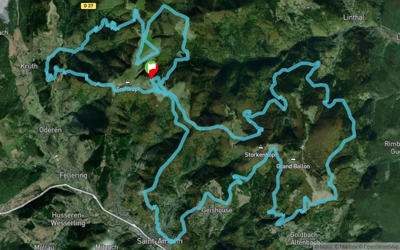


70.5 km
3360 m
3360 m
 Oderen (68)
 6
6 430
430 Points of Interest table
| Accum. | Intermediary | |||||||
|---|---|---|---|---|---|---|---|---|
| POI | Description | Alt. | Dist. | D+ | D- | Dist. | D+ | D- |
 Competition organized on 05/02/2020
Trace n°45418
Ascent threshold : 0 m Distance threshold : 30 m Smoothing : Yes Origin of altitudes : MNT IGN
Ascent threshold : 0 m Distance threshold : 30 m Smoothing : Yes Origin of altitudes : MNT IGN
Loop
Dominant terrain : Footpath
Max alti. : 1277 m
Avg alti. : 957 m
Min alti. : 419 m
Longest ascent : 830 m
Longest descent : 760 m
Dominant terrain : Footpath
Max alti. : 1277 m
Avg alti. : 957 m
Min alti. : 419 m
Longest ascent : 830 m
Longest descent : 760 m
Elevation profile
More tools
Create a new roadbook page
Map and track on your website
Warning ! When you insert a Trace de Trail map on your website, you agree not to hide any element of the module (links to Trail Trail or Trail Connect banner)
Add a realisation
Validate
Add a realisation to share your chrono and describe the conditions that you encountered during you trail running !
Add a comment
Validate
guillaumebruyr
02/02/23, 11:38:50
Hello, Would it please be possible to allow downloads of the GPX file in order to use GPS tracking during the run? Thanks, Guillaume
02/02/23, 11:38:50
Hello, Would it please be possible to allow downloads of the GPX file in order to use GPS tracking during the run? Thanks, Guillaume
Admin - Trace de Trail
16/08/19, 14:06:23
Bonjour, Merci de dupliquer votre trace pour l'édition 2020 ou de changer la date de compétition...
16/08/19, 14:06:23
Bonjour, Merci de dupliquer votre trace pour l'édition 2020 ou de changer la date de compétition...
More comments
NielsKok
21/04/18, 15:44:24
Hello Sportevents, could it be possible that the gpx of the 70km is not correct. It seems to be the gpx of the 48km.
21/04/18, 15:44:24
Hello Sportevents, could it be possible that the gpx of the 70km is not correct. It seems to be the gpx of the 48km.
NielsKok
14/04/18, 10:11:23
Hello, is it possible that you'll sent me the gpx as well? I want to use it during the race (on my suunto).
14/04/18, 10:11:23
Hello, is it possible that you'll sent me the gpx as well? I want to use it during the race (on my suunto).
bartvanhoenacker
12/04/18, 20:15:37
Dear, Would it please be possible to allow downloads of the GPX file in order to use GPS tracking during the run? Kind Regards, Bart
12/04/18, 20:15:37
Dear, Would it please be possible to allow downloads of the GPX file in order to use GPS tracking during the run? Kind Regards, Bart
Show the infos
Warning ! This track is only accessible on the day of the competition.
Add a track